| Thursday, 27th June 1996
|
|
I'd decided to stay here in Oban for two nights and to take an
all-day "Three Islands" trip, departing on the early morning
ferry. It was only a short walk from the guest house to the port,
with plenty of time for breakfast before leaving.
|
|
|
Caledonian MacBrayne's
"Isle of Mull" arrived and turned around very quickly, only
spending about twenty minutes tied up to the dock and departing on
time. This was a full-sized seagoing ship which in addition to this
short route also travels further west to the islands of Coll
and Tiree (about 4 hours away). First of all we headed
north out of the bay and past the tip of Kerrera island (which
shelters Oban from all but the worst weather), before turning
north-west across the Firth of Lorn. Very soon we
passed the lighthouse guarding the southern tip of Lismore
island, and then approached Mull for the first time with an
excellent view of Duart Point and its castle lit up by the
sun. From here it was a short run (the entire crossing having taken
about forty minutes) across the bay to the ferry port at Craignure.
|
|
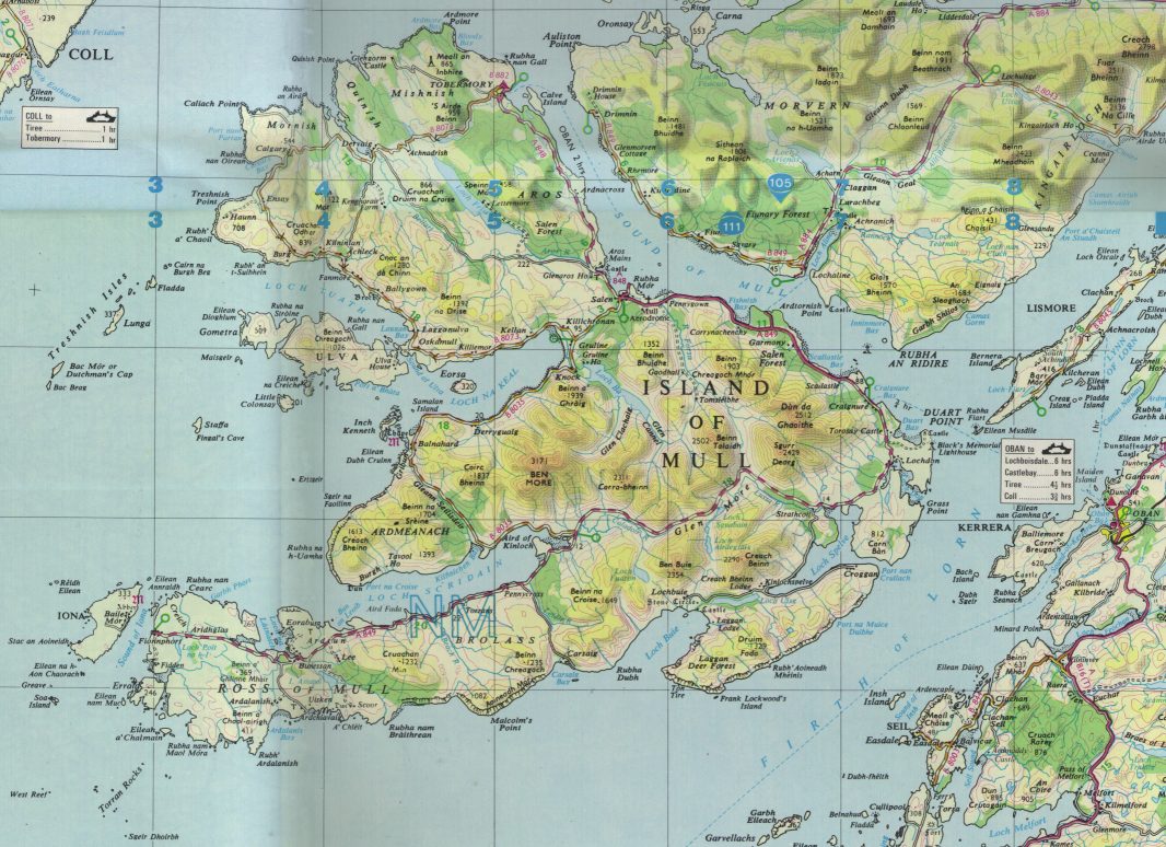
![[Island Map]](pics/mull5s.gif)
Map of Mull and the surrounding islands
(234K JPEG)
(89K JPEG)
|
|
![[Tobermory]](pics/tobermory1s.gif)
Tobermory town and harbour
(71K JPEG)
|
|
A fleet of coaches were waiting here to take the various parties
onwards: I managed to locate the appropriate one, which turned out to
be the only one running this particular trip (with a total of about
twenty people). We set off northwards out of the town ("town"
used here is a relative term: Tobermory in the north of the
island is probably the largest, with most of the others being simply a
collection of a few houses and maybe some shops and a pub) and along
the main coast road. Along here and throughout the trip, the driver
gave us an excellent commentary on the sights to be seen and some
interesting insights into island life.
|
|
|
Here is the sort of place where one could get away from it all and
still retain some trappings of civilisation: although there is much
tourist traffic at this time of year, the island is quiet and isolated
in the winter (which, however, are not particularly cold - the
Gulf Stream reaches even to here! - although it is often very
windy on the seaward coast). Mull and its outlying islands
together have a population somewhat less than a thousand, but there is
apparently no shortage of employment: in addition to conducting coach
trips in the summer, our driver breeds angora rabbits for a living
(collecting and selling their wool), and is also a part-time
coastguard and worked as a truck driver for the water pipeline
project. Vehicle ferries run from Tobermory and Craignure
to the mainland, with a passenger ferry from Ardtornish Point
across to Lochaline; there is also a small landing strip near
Salen for light aircraft. Obviously, anything needed from
outside has to be brought over on the ferry; the island has some
primary schools (secondary pupils travel to boarding schools on the
mainland) and limited medical facilities (urgent cases are taken to
the mainland either by lifeboat or by helicopter).
The island's main products are fish and timber, as well as the
inevitable cattle and sheep (which are kept mainly for
mutton - the wool that these hardy breeds produce is too
coarse for clothing and is really only useful for carpets).
We continued northwest along the coast road, with the
Sound of Mull (roughly two miles wide) on our right
and the mainland clearly visible. This part of the island is fairly
flat, with pine forests reaching up to the mountains inland, and with
small villages spread out along the road. At the Salen
junction we turned left and the scenery began to change: as we headed
towards the west coast the forests gave way to peat moors (still
widely used for fuel) with isolated farms and houses the only signs of
life. Emerging onto the coast again at the head of
Loch na Keal, we turned right along its northern
shore and followed the road (which was becoming increasingly narrow
and steep!) to finally end up at the landing stage just opposite
Ulva island, only a hundred yards or so across the water.
Ulva is inhabited (although it has no main roads), and a ferry
boat crosses from here to the island. We didn't do that, but instead
boarded the "Hoy Lass" (a small twin-engined workboat, thankfully
with an enclosed cabin) and set off southwards past the island and
into the open sea. The boatman again gave us an interesting
commentary as we passed Eorsa island (mainly flat, but with
high cliffs at its seaward end; German VIPs were interned here during
WW II) and Little Colonsay (now a bird sanctuary).
Inch Kenneth to the south (with its old monastic
settlements) is linked to the land by a line of broken rocks fallen
from the unstable Gribun cliffs above: it is said that the
bodies of an 18thc couple, whose cottage
was crushed by a falling boulder on their wedding night, still lie
here...
Ahead was Staffa, our next destination; beyond that, the three
Treshnish Isles could be seen, with Tiree and
Coll just visible in the distance.
|
|
|
Staffa island is formed out of hexagonal basalt pillars (similar
to the Giant's Causeway) with a crown of broken rocks and
soil. It has never been inhabited, apart from the occasional hermit,
and is now owned by the NT and kept as a nature reserve: there are no
natural harbours and the only man-made constructions are the landing
stage and the walkway leading to the cave. We approached it from the
south - having taken some fifty minutes to get here from
Ulva - so as to get as close as possible to the island's
main attraction, the black hole of Fingal's Cave set into the
cliffs. The cave is named after Finn MacCool, a legendary Irish
hero, and gets a mention in Mendelssohn's 'Hebrides Overture' (he
was apparently an avid traveller, although visiting the island must
have been far more difficult in his time!). It also features in the
film "When Eight Bells Toll",
where Calvert can be seen firing a flare into the cave.
|
|
![[Fingal's Cave]](pics/staffa1s.gif)
Fingal's Cave from the sea
(117K JPEG)
|
|
![[Inside the cave]](pics/staffa3s.gif)
Inside the cave
(51K JPEG)
|
|
After sailing back and forth past the cave several times - mainly
to give everybody time to take photographs, although also to kill time
until the tide had risen sufficiently - the boatman brought us up
to the landing stage. This was a very skilled operation given the
state of the sea and the wind, and the rocks that we had to squeeze
past! - but we arrived there safely, and everybody left the boat
to explore the island for an hour or so.
There are only two ways to go from here, the first of these being a
narrow walkway (thoughtfully provided with a wire handrail) across the
tops of the columns to the mouth of the cave. It was even more
spectacular to stand here with the roof high above and the sea rushing
in and out just below: naturally, since the rock is black the interior
of the cave is dark and forbidding. The walkway continues a short way
into the cave (but not quite as far as the back wall, some
230 feet from the entrance); looking back outwards,
Iona island (our next destination) was clearly framed in the opening.
|
|
|
After visiting the cave I returned to the landing stage and climbed up
the steps to the top of the island, covered in grass but with nothing
larger than a gorse bush growing. There are seabird colonies among
the cliffs to the north, but there was no time to go all the way there
and back; instead I watched as the boat returned to the landing stage
(a slightly easier operation this time, as the tide had risen further)
and then we set off southwards on the next stage of our journey.
|
|
![[Boat at Staffa]](pics/staffa2s.gif)
Eight miles out into the Atlantic, in this?
(77K JPEG)
|
|
|
Iona island is separated from the western tip of the
Ross of Mull by a mile or so of sea: it is
mostly flat and green, with hills rising to some 330 feet
in the north, and - unusually for these parts - has beaches
with fine silver sand. Its first religious settlement was founded in
the 6thc by St.Columba, an Irish monk who went on to
establish a series of similar communities throughout Scotland
and northern England. This initially flourished (the famous
Book of Kells was probably written here in the
mid-8thc, and many crosses and monuments remain from
this period), but after Viking raids in the late
8thc most of the community returned to
Ireland. Some devoted monks and hermits remained, but in the
early 13thc the present Benedictine abbey was
established under the patronage of the powerful MacDonald clan, the
Lords of the Isles. After the Lordship was forfeited in the
15thc, the abbey was caught up in the religious
turmoil of the time and gradually declined; by Victorian times the
buildings were ruined and the community had again been dispersed.
Tourist travel to the islands reawakened interest: the buildings were
restored in the early 20thc, and in 1938 the current
Iona Community was founded (an
offshoot of the Church of Scotland) who now hold the buildings in
trust; the remainder of the island is owned by the Scottish NT. It
has a permanent population of about 100.
|
![[Iona Abbey]](pics/iona1s.gif)
Iona abbey, looking over the Sound of Mull
(77K JPEG)
|
|
We passed through the Sound of Iona to the island's
only village, on the eastern shore facing the Ross of Mull,
and tied up to the pier - the crossing from Staffa having taken
about forty minutes. Here we finally left the boat, having about
1½ hours to explore the island before catching the ferry back.
I set off along the island's only main road through the village, first
passing the ruined nunnery (dating from the same period as the
Benedictine abbey) and the present parish church with the 15thc
Maclean's Cross still standing in front of it. This is almost at
the edge of the village: a short way further on is the abbey and its
grounds.
|
|
Two 8thc crosses stand in front of the abbey
buildings. St.Martin's Cross is the original, still standing in
its granite base, but the spectacular St.John's Cross (with a
2¼ metre span, the largest of any such cross in
Britain or Ireland) has been moved to the abbey museum
and a concrete replica now stands here. The local stone is unsuitable
for carving such monuments (even with the typical Celtic reinforcing
rings), and the raw material for both these crosses was apparently
brought over from the mainland.
From the crossroads in front of the abbey, the medieval paved Road of
the Dead led to St.Oran's Chapel and its burial ground. Legend
has it that ancient Scottish, Irish and Norse kings are buried here,
but there is no evidence to support that and the earliest tombs here
are those of various lords and clan chiefs from the
15thc. In modern times the burial ground has been
used exclusively for island residents and members of the religious
community: special provision was made for John Smith, buried here
in 1994.
|
|
![[Crosses]](pics/iona2s.gif)
From left to right:
Maclean's Cross,
St.John's Cross (replica),
St.Martin's Cross
(115K JPEG)
|
![[Iona village]](pics/iona3s.gif)
Iona village and harbour
(100K JPEG)
|
|
After exploring the abbey, its museum and the burial ground, it was
time to return to the village and catch the ferry back to Mull.
Caledonian McBrayne again, of
course: the "Loch Buie" runs a regular passenger and vehicle
service, although permission is required to take any motor vehicle
across to Iona which is normally only granted to permanent
residents. This took some ten minutes to cross to Fionnaphort
(pronounced "Finafore" to rhyme with "pinafore"), the end of the main
(and only!) road along the Ross of Mull where our
coach was waiting.
|
|
|
From here back to the east coast is probably the longest journey that
can be made on the island, nearly forty miles. The first village that
we passed through after leaving the port was Bunessan, at the
head of Loch na Lathaich. In the
19thc a lady living here wrote a number of hymn
tunes: one of them, named after the village, is probably better known
nowadays as "Morning has Broken". From here the road
followed the southern shore of Loch Scridain, where we
stopped to watch seals resting on the rocks. The Ardmeanach
peninsula to the north rises some 1600 feet out of the sea
in huge steps; along its southern shore, McCulloch's Tree, a
fossil some forty feet high and fifty million years old, looks out
southwards over the loch.
Halfway along the road we came to the junction at Kinloch:
normally this means "head of the loch" and is always associated
with the name of a loch, but here it suffices as a name alone. After
leaving the sea here we followed the Coladoir river through
Glen More, passing between Ben More (the
island's highest mountain, 3171 ft) to the north and
Ben Buie (2354 ft) to the south. This road is
fairly recent, but it follows an older military road constructed in
the 17thc and in use until the mid-20thc;
we followed some long stretches of this old road, with its many stone
bridges still standing. As we passed the "Three Lochs"
(Loch Airdeglais, Loch Sguabain and a small
unnamed one) the driver told us the local legend of
Ewan-of-the-Small-Head
(follow the link for the full story).
Almost at our journey's end, we passed through the tiny village of
Lochdon - with its own post office, apparently due to
local demand, in a hut somewhat smaller than a garden shed -
and then the two castles on the eastern tip of the island, Torosay
with its private railway connecting it to the port and Duart on the
headland overlooking the firth. Unfortunately there was no time to
visit either of these (but they will definitely be worth a repeat visit
some time). Finally we reached Craignure and left the coach for
the last time, to board the "Isle of Mull" again for the
journey back to the mainland.
|
|
|
The journey back again took about forty minutes, arriving at
Oban late in the evening where it was time for a very welcome
meal - there having been no other opportunities to eat on the trip,
although packed lunches were being sold on the ferry this morning.
And I really should have got one...
The weather is always unpredictable in this part of the world: today
started off rather dull, but it cleared up on the island although the
sun didn't really come out until late in the afternoon. It was windy
at sea, which made the small boat rather bumpy, although it (and the
passengers!) handled the conditions well.
|
![[Island Map]](pics/mull4.jpg)
![[Tobermory]](pics/tobermory1.jpg)
![[Fingal's Cave]](pics/staffa1.jpg)
![[Inside the cave]](pics/staffa3.jpg)
![[Boat at Staffa]](pics/staffa2.jpg)
![[Iona Abbey]](pics/iona1.jpg)
![[Crosses]](pics/iona2.jpg)
![[Iona village]](pics/iona3.jpg)